
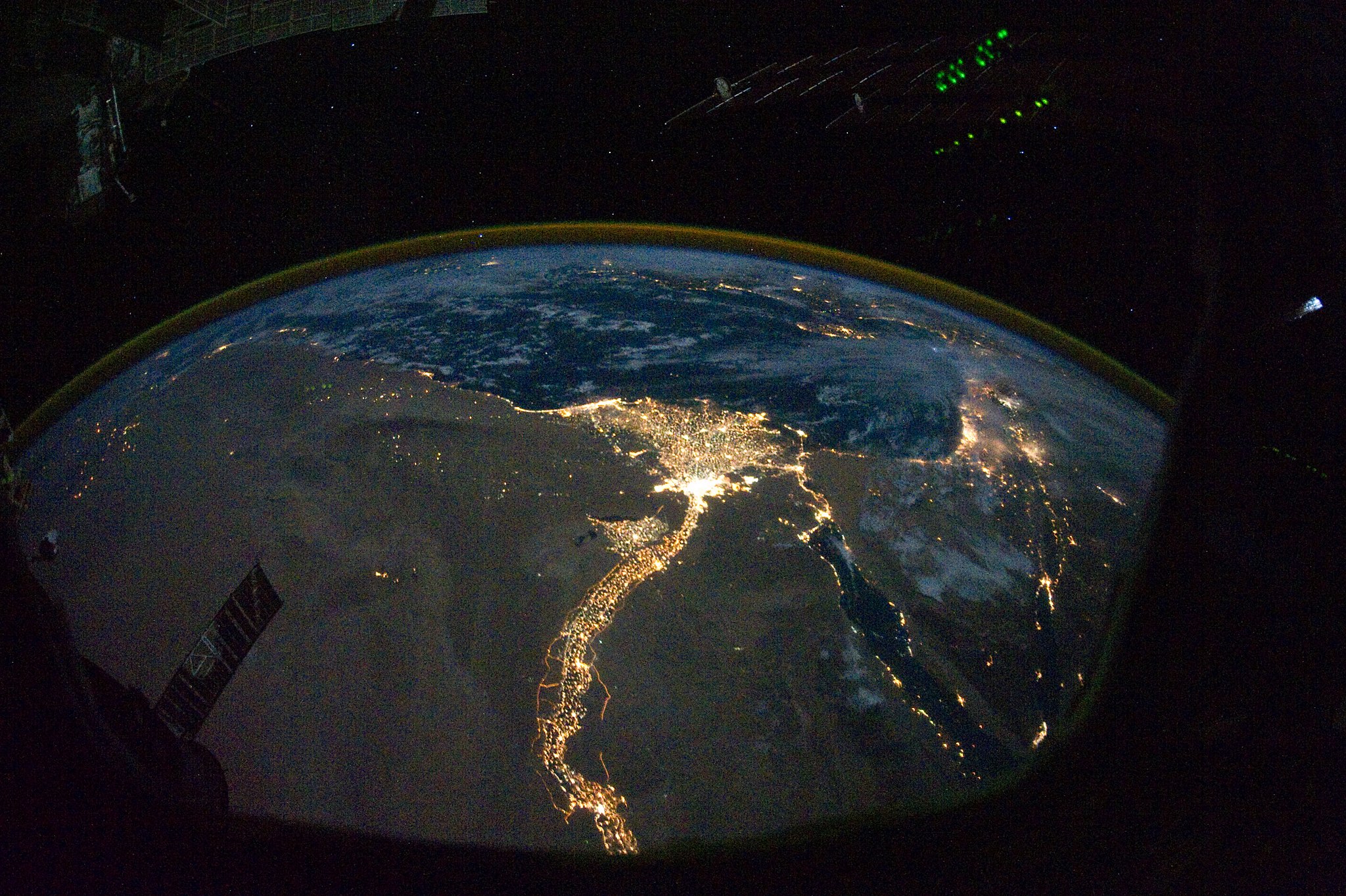
Nile Delta at night, NASA Earth Observatory 2010. Public Domain.
The first Coastal History Blog post to engage with rivers was in 2014, when I blogged about the “Rivers of the Anthropocene” conference that I attended in Indianapolis. This conference later resulted in a fine interdisciplinary volume edited by the historian Jason Kelly and the other organizers. More recent scholarship on rivers includes the widely admired book by Debjani Bhattacharyya, Empire and Ecology in the Bengal Delta: The Making of Calcutta (Cambridge: Cambridge University Press, 2018) and the volume edited by Thaïsa Way, River Cities: City Rivers (Washington, D.C.: Dumbarton Oaks Research Library, 2018). The chapters in that volume cover multiple continents and a tremendous chronological range.
In October 2019 (which already feels long ago), I participated in a workshop organized by Craig Colten and Iris Borrowy on “Delta/Coastal Cities and Environmental Change” held in Shanghai; a special issue of a journal is in the works, so keep an eye out for that before long. At the Shanghai workshop, I met Jenia Mukherjee, who patiently introduced me to some themes and intellectual trends I’d missed out on, notably the literature around the “hydrosocial.” I should also mention that Mukherjee’s fascinating work on life along the “chars” (sandy shoals) of the Ganges Delta in the present day is a good reminder, to people like me who are a little too fixated on cities, that river history is also rural history.
Today’s post, by Sam Grinsell, takes us not to the Ganges, but to the Nile. I’ve often suggested that coastal history is what happens when scholars come to a shoreline from some unexpected direction, and I’m delighted to see how often that is borne out, often in ways (and from directions) that I never anticipated myself. — I.L.
The British Empire seized control of the Nile valley at the Battle of Omdurman in 1898, at the confluence of the Blue and White Niles. An army of predominantly Egyptian troops led by Horatio (later Lord) Kitchener crushed the forces of the Khalifa, who had ruled Sudan since 1885. Before then, Egypt had been the colonial power in the region since the 1820s. After the battle, the combined Anglo-Egyptian forces unleashed their wrath on the defeated Sudanese, killing thousands who they could have taken prisoner.[1]
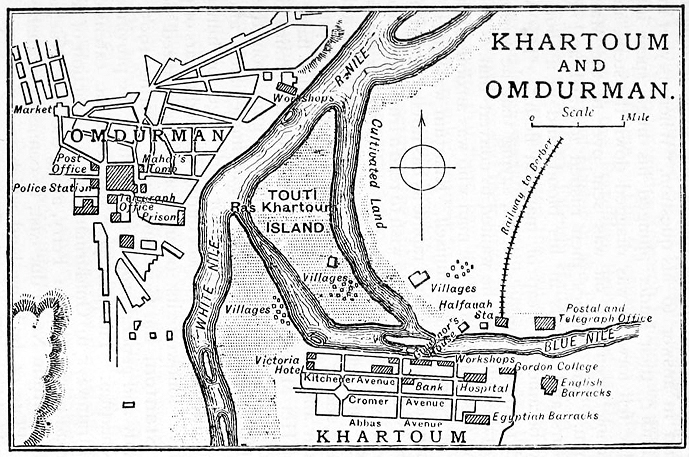
Map of Khartoum and Omdurman in 1905, E. A. W. Budge, Cook’s Handbook for Egypt and Sudan, (London, 1906), Public Domain.
Omdurman had been built by the followers of Mohammed Ahmad, a Muslim holy man proclaimed by his supporters to be the Mahdi, a figure of prophecy who would be the herald of the second coming. After he died, it became the seat of power for his successor, the Khalifa. Omdurman lay on the western bank of the Nile, across the water from the previous capital, Khartoum, which the Sudanese largely abandoned after driving out the Egyptians and the British in the 1880s. Following the Battle of Omdurman, Kitchener and his aides drew up plans for the reconstruction of Khartoum as a new colonial capital.[2]
My own research on the history of the Nile valley began at the confluence; whereas colonial forces arrived there from the coast, I have moved in the other direction. I began with the urban history of Khartoum, approached through All Saints’ Cathedral, which was built with charitable funds in the early twentieth century.[3] In seeking to read this building and its place in the wider space of colonial Khartoum, I found that I had to draw on wider and wider environmental and institutional networks to understand the making of the region. This process of expansion led to my PhD thesis ‘Urbanism, Environment and the building of the Anglo-Egyptian Nile valley, 1880s-1920s’, recently completed at The University of Edinburgh.
The more I worked on colonialism in the Nile, the more I wanted to understand what empire had meant for the river. This might seem an odd question: what does a river care about human politics? But European colonialism in the region was deeply concerned with water. French engineers opened a canal from the Red Sea to the Mediterranean in 1869, radically reworking global trade as goods no longer needed to be dragged over the land route between Asia and Europe. British engineers restored and extended the systems of barrages and culverts that sought to harvest the Nile flood, and in the early twentieth century dammed the river at Aswan.[4] In any case, river waters are always in complex relation with human activities: waste from the people and creatures who live along the Nile’s banks is carried northwards, mingling with the soils and dust of all the landscapes passed by the world’s longest river. This rich mineral cocktail has, for millennia, produced the fertile earth of the Nile delta. But this system has been rewritten by colonial engineering of the river, so that the delta is now in retreat. The history of empire has thus been inscribed upon the coast.
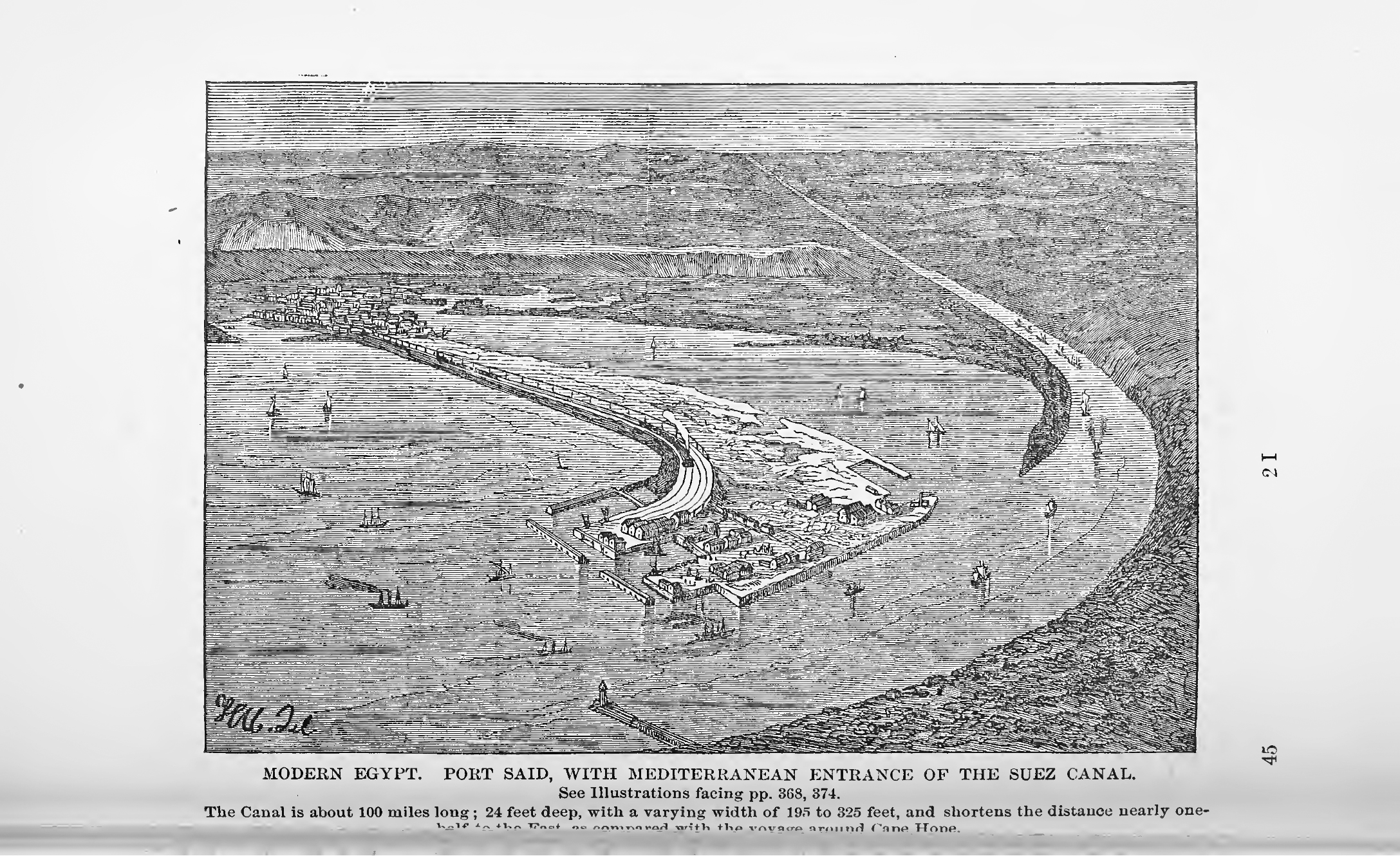
Port Said harbour, from Rev. Joseph Angus, The Bible Hand-book: an introduction to the study of sacred scripture (Philadelphia: J. Fagan & Son, 1883), Public Domain.
In planning the expansion of twentieth century Alexandria, on the western fringes of the delta, William McLean sought to constrict the urban zone to a narrow strip close to the shore.[5] Any land reclaimed from the lakes that lay to the south would command greater value as fields for agriculture than as building sites. Today, lakes and wetlands still lie to the south of Alexandria, though some have been drained to make way for Alexandria International Airport. The city is still long and narrow, strung out along the coast just as McLean planned. Away from the historical core, opulent villas with sprawling grounds monopolise the coast itself. The form of this city is, thus, a product of complex interactions between land, water, economics and power.
The same is true to the east of the delta. Port Said was built as the gateway to the Suez Canal, and is also hemmed in by lakes to the south and sea to the north, as well as the canal itself to the east. It was painstakingly constructed on a spit of desert land by workers gathered from the poor and desperate of the Mediterranean basin.[6] As part of the Suez project, it was seen as one element in a great technological triumph of modernity. But we can also view it as just one further chapter in the ongoing watery relations of the urban coast.
Thus, pursuing the history of a river drew me to the rich intertwinings of coastal history. Empire transformed land/waterscapes, but was itself also made through such environmental processes and relations. The history of imperial modernity is not, in my view, as much about an actual mastering of – or breaking away from – the environment, but is rather a new entangling of ways of being. As well as controlling human lives and deaths, it was also an attempt to write human hierarchies onto the planet on which we live, and the ambiguous successes and devastating failures of this attitude created the multiple ecological crises in which we live. The coast has often been a place where these new environmental relations are negotiated and produced, and by studying coastal histories we can better understand the unstable environments in which we seek to build liveable futures.
Notes
[1] Martin W. Daly, Empire on the Nile: The Anglo-Egyptian Sudan, 1898-1934 (Cambridge: Cambridge University Press, 1986).
[2] Adil Mustafa Ahmad, “Khartoum Blues: The “Deplanning” and Decline of a Capital City,” Habitat International, vol. 24, no. 3 (2000): 309–25.
[3] Robin Cormack, “Unity Out of Diversity? The Making of a Modern Christian Monument in Anglo-Egyptian Sudan,” in From Plunder to Preservation: Britain and the Heritage of Empire, C.1800-1940, ed. Astrid Swenson and Peter Mandler, Proceedings of the British Academy (Oxford: Oxford University Press, 2013), 63–90.
[4] Claire Jean Cookson-Hills, “Engineering the Nile: Irrigation and the British Empire in Egypt, 1882-1914” (PhD thesis, Queen’s University (Canada), 2013); Jennifer L. Derr, The Lived Nile: Environment, Disease and Material Colonial Economy in Egypt (Stanford, California: Stanford University Press, 2019).
[5] W. H. McLean, Regional and Town Planning, in Principle and Practice (London: The Technical Press ltd., 1930).
[6] Lucia Carminati, “Port Said and Ismailia as Desert Marvels: Delusion and Frustration on the Isthmus of Suez, 1859-1869,” Journal of Urban History vol. 46, no.3, (2019), 622-647.


Comments are closed.